As the waterline rises, the tide engulfs further archaeology and keeps its secrets for centuries. In this blog, Fathoming The Future volunteer Benita Yue, gives a brief insight into several projects undertaken by the Maritime Archaeology Trust. Each project telling the story of several eras lost under the waves.
Figure 1: A painting showing the rising waterline, by Mike Greaves
PREHISTORY
Many of the MAT’s projects are located around the Solent, a strait between the Isle of Wight and mainland Britain, forming a submerged valley of a former east flowing river (Britannica, 2019). The MAT is well placed to respond to historical sites around the Solent, an area long recognised for the importance of its marine heritage, and the highest potential for maritime heritage in England. The Solent Marine Heritage Assets Project has been instrumental in providing funding to enable the MAT to work with England Heritage to effectively manage, research and monitor heritage assets.
Bouldnor Cliff
A kilometre east of Yarmouth, off the Isle of Wight, Bouldnor Cliff is the only known site of a submerged prehistoric settlement site in the UK. It lies within the Solent Maritime Special Area of Conservation and is in the Yarmouth to Cowes candidate Marine Conservation Zone. The site features ancient forest of pine changing to oak, hazel and alder, and flooded by rising sea levels. Since the 1990s, regular diving, monitoring and research by the MAT has uncovered a technologically advanced culture for the time period, with numerous worked flints, flakes and tools, and evidence of boat building, with findings of worked wood and string composed of twisted plant fibres. Seasonal or semi-permanent settlement covers an area of several 100 metres of coastline. Radio carbon dating and palaeoenvironmental analysis of artefacts suggest links with Southern Europe or the North European plain before the formation of the North Sea. As with many marine archaeological sites, Bouldnor Cliff is threatened by coastal erosion, both exposing more artefacts and contribute to their loss, so it is important that further work is continued.
ROMAN
Itchen River Project
The Itchen River feeds into Southampton Water. Upstream lies Winchester, an important regional capital in Roman times, known as Venta Belgarum, indicating the River was important for trade and communications (Southampton Canal Society, 2021). Winchester was also settled by the Saxons.
The Itchen River Project was a collaboration from 1997 to 2002 between Southampton City Council Archaeological Unit, the MAT, local community volunteers and students of Southampton University and University College London, and the University of Portsmouth developed the GIS survey. Most notable finds included wooden posts at St Denys opposite Bitterne Manor, the site of the Roman settlement Clausentum. Dated to AD201, the posts were believed to be remains of a Roman waterside structure with pier, jetty and wharf.
Figure 2: Image of the Roman waterside structure surveyed for the Itchen River project
MIDDLE AGES
Langstone Logboat
The discovery of a logboat in Langstone Harbour was part of the Langstone Harbour Project, in which the MAT has been involved in since the early 1990s. The MAT, as part of a multidisciplinary team including Portsmouth University, Southampton University and Wessex Archaeology, undertook extensive underwater searches, surveys and excavations of numerous artefacts uncovered by the erosion along the area’s islands and mudflats. Among the artefacts were Neolithic arrowheads, Bronze Age cremation urns, Roman pottery and remains of Medieval Saltworks. The logboat was found fractured by time and tide, and was radiocarbon dated to around AD500. The logboat is on permanent display at Portsmouth City Museum, alongside uncovered Saxon jewellery and weaponry, prehistoric flint and a Bronze Age torch illustrating the significance of the area over multiple historic periods. The logboat and the surrounding area is being further investigated as part of the Arch-Manche project.
RENAISSANCE
Yarmouth Road Shipwreck
A shipwreck was discovered in 1984 during an archaeological survey of the seabed off Yarmouth, as part of the Isle of Wight Heritage Project. It is now a designated Protected Wreck. Timber and pewter plates dated the wreck to the 16th century; later finds included a bronze pestle, a rare bronze cannon, a bone comb and almost intact pottery jugs of Mediterranean origin, now on display at the Shipwreck Centre and Maritime Museum. The shipwreck is likely to be the Spanish Santa Lucia, a 30-metre-long ship (large for its time), lost at sea at Yarmouth whilst sailing to Flanders in 1567 with a cargo of wool.
Financial constraints stalled further active investigation, but sandbags were used to protect areas of the site, and monitoring was continued to ensure the site’s stability. In 2004 the MAT (then the Hampshire and Wight Trust for Maritime Archaeology (HWTMA)) became the Licensee for the Yarmouth Roads Protected Wreck Site, the initial project being one of the driving forces behind the formation of the HWTMA. In 2004 an inspection was carried out in conjunction with the Solent Marine Heritage Assets Project, the survey indicating the site was relatively stable.
Between 2015 and 2018, a collaboration with the ForSEAdiscovery and the MAT renewed research of the shipwreck at Yarmouth. ForSEAdiscovery is a European funded project that combines dendrochronology, archaeology and history to understand timber supplies for the construction of early modern vessels in the Iberian Peninsula (Nayling et al., 2018), and how shipbuilding in the 16th to 18th centuries may have impacted past Iberian forests. The sampling of timber of the shipwreck at Yarmouth, provides valuable information for the project, and increases understanding of the ship itself, and its wider socio-economic, political, environmental and even philosophical context during a period of rapid and widespread change.
ELIZABETHAN
Shingles Bank Wrecks NW96 & NW68
Discovered by Isle of Wight based divers Martin Pritchard and Dave Fox, two historically significant wrecks lie on the Shingles Bank. Martin and Dave’s research of the site, with the support of the MAT, have led successfully to the site’s formal Protected Wrecks status.
NW96 is believed to be the later 15th Century/early 16th Century remains of an armed merchant ship carrying a cargo of lead ingots and stone cannonballs. NW68 carries numerous cannons, one of likely Dutch origin, which was dated between 1621 and 1661. It may have been involved in the Battle of Portland in 1653, when the Commonwealth of England fleet was attacked by the Dutch Republic.
In 2021, Historic England, Martin, Dave, Wessex Archaeology and the MAT undertook a detailed survey of the site with high resolution photographs to build a 3D model. There are plans to develop virtual dive trails for anyone wishing to discover the site for themselves.
Figure 3: Archaeologist Christin Haemagi recording timber structure on the NW68 site
Spanish Galleon Santiago de Galicia at Ribadeo, Spain
This project was another successful collaboration with ForSEADiscovery, for a shipwreck, the Santiago de Galicia, found in Ribadeo, a port town in Northern Spain.
The Santiago de Galicia was a Spanish warship, part of a second set of galleons designated as ‘The Apostles’ built to secure Atlantic routes from pirates and privateers, and protect routes of wealth into Spain (San Claudio et al., 2023). As part of the Armada against England, Santiago de Galicia was a large ship for its time transporting artillery and soldiers. It ran aground in 1597, and was discovered during dredging works of the Ribadeo estuary in 2011 (San Claudio et al., 2023). The MAT has contributed to the project using photogrammetry to provide 3D reconstructions of the site, and a recovered cup from the ship.
Photogrammetry becomes an increasingly powerful resource in archaeological reconstruction. The technique extracts 3D information from overlapping photos of objects to produce digital model reconstructions. This is particularly important where objects are too fragile to be handled.
Figure 4: Santiago de Galicia, Ribadeo ’19 pre-disturbance. You can find more 3D models of the site here
GEORGIAN/VICTORAIN
HMS Invincible
HMS Invincible was originally a French warship named L’Invincible, captured by and recommissioned by Britain in 1767 as Invincible for the Royal Navy. It ran aground off Portsmouth, and was found in 1979, becoming a legally Protected Wreck in 1980. Supported by the Heritage Lottery Fund, the MAT helped to make research archives publicly available via an interactive viewer. Further artefacts were discovered during monitoring with the Solent Marine Heritage Assets Project. Continuing work began under the collaboration of the Maritime Archeological Sea Trust and Bournemouth University.
Fenna
The Fenna was a two masted Dutch sailing schooner built in 1862 for transporting raw material and manufactured goods around Northern Europe. In 1881, enroute between Antwerp and Sicily the Fenna encountered heavy gales, causing the crew to abandon ship, the vessel sinking off the Needles off the Isle of Wight. The wreck was discovered in 1981, following sound testing in the area by the UK Hydrographic Office, and later confirmed in 1988, and dived by a local historian Dave Wendes in 2000. Wendes and the MAT joined forces in ongoing research of The Fenna, highlighting particularly good preservation of its cargo of railway lines, glass sheets and concrete. Its lower hull parts are well preserved, and the wreck provides important artificial reef habitat for a wide diversity of marine life.
The Offshore Aggregates and Species Inhabiting historic wreck Sites (OASIS) project was setup through The Wildlife Trusts South East Marine Programme and Natural England, aimed to demonstrate the importance of the marine environment, and the interdependence of seabed deposits, sea life and historic shipwrecks. OASIS carried out research to record marine life on the Fenna, with notable organisms including shipworm and gribble in the timbers, and numerous lobsters and bib.
The incorporation of the Fenna into the Solent Maritime Heritage Assets Project has allowed the MAT to continue monitoring the site, producing a formal site assessment of the Fenna on behalf of English Heritage. The Fenna may represent ongoing use of purely wooden hull construction in a time when iron was increasingly integrated into ship building. It is likely the remains are representative of the local or regional traditions of ship building. Further investigation of its cargo has the potential to provide information into the type of materials being shipped around Europe at this time.
MODERN
Forgotten Wrecks of the First World War
The Forgotten Wrecks of the First World War was a Heritage Lottery Funded project from 2014-2018, coinciding with the centenary of the Great War. Much attention around WWI is concentrated on the Western Front and major naval battles like the Battle of Jutland, but much history remains undiscovered and unprotected, particularly around the South coast of England. Over 1800 days of volunteer work were central to this project, researching the more than 1100 wartime wrecks along southern England, and to bringing a program of school presentations, talks, public awareness and exhibitions of the Forgotten Wrecks. Archaeological reports, booklets, geocaching and 3D modelling were produced, and a database made to create a lasting legacy and resource base for future generations.
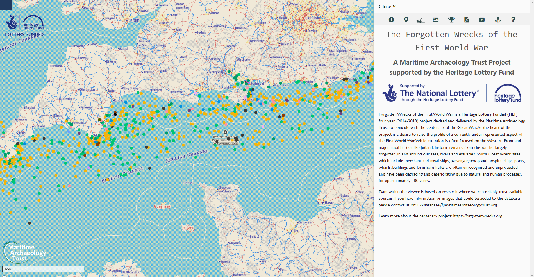
Figure 5: The Forgotten Wrecks database showing many South Coast wreck sites from the First World War
Landing Craft 2428
The Landing Craft Project, funded by English Heritage, was a collaboration between the MAT and Southsea Sub-Aqua Club (SSAC) to survey the remains of LCT(A) 2428, a WWII landing craft that sank in the eastern Solent in 1944. Originally loaned from the USA to the UK, the vessel was designed to carry 2-3 tanks that would provide heavy fire power support. The LCT(A) 2428 was the leader of the 105th Flotilla of Assault Group J1 Support Squadron, assigned to Juno beach to support the 7th infantry of the 3rd Canadian Division at Sourseulles-sur-Mer. On 5th June 1944, the vessel had engine trouble, and despite attempts at rescue by the tug HMS Jaunty, capsized and lost its cargo. HMS Jaunty fired to sink the landing craft to remove the potential navigational hazard. The Landing Craft was first investigated by the SSAC in 2008, its remains spread over two sites, one site with vehicle and equipment onboard, the other with the remains of two tanks, two armoured bulldozers and vehicles. In 2010 SSAC joined forces with the MAT to produce a 3D site plan and establish monitoring points. The information provided from investigations would inform assessment of the potential benefits of statutory heritage legislation, providing a case study of the protection of English underwater archaeology.