In our developing world, underwater cultural heritage is vulnerable to the big changes we are making to our coastline, environment and waters. One of the biggest threats is from erosion. Volunteer Benita investigates what is being done and asks the vital question – how do we manage and protect underwater cultural heritage from the threat of this issue?
How is erosion threatening underwater cultural heritage?
Whilst maritime archaeological sites are often only discovered and exposed by erosion from waves and currents, these also have the potential to wash them away. There is growing evidence climate change is bringing more storms at increasing severity. The prehistoric settlement site at Bouldnor Cliff in the Solent has experienced up to four metres of lateral erosion over a period of ten years; exposure of the underlying plant and tree root system to erosion could further accelerate this. Due to water currents and topography, the constantly shifting sandbanks of Goodwin Sands were a renowned historical navigational shipping hazard before navigational aids such as lighthouses were installed, and became the graveyard of many ships (Ramsdale, 2022). Remains of shipwrecks, such as the Rooswijk, on the Goodwin Sands are at continual threat of exposure, decay and collapse, despite it being a designated Protected Wreck (Beattie-Edwards, 2018).

Figure 1: Exposed wreck on the East Winner Bank, Maritime Archaeology Trust
Once exposed, maritime archaeology is under threat from bioerosion. Marine organisms like shipworm and gribble feed and live inside wooden structures and making them more vulnerable to collapse. We have seen evidence of this on shipwrecks such as the Mary Rose off Portsmouth, and the Flower of Ugie in the Eastern Solent. There are also indications that warming waters are encouraging the migration of more species of boring organisms into British waters (Palma & Santhakumaran, 2014). In waterlogged environments or where archaeological remains are covered by sediment, there is less oxygen for marine borers to survive, but microbial degradation by bacteria and fungi can be found, albeit at a slower pace.
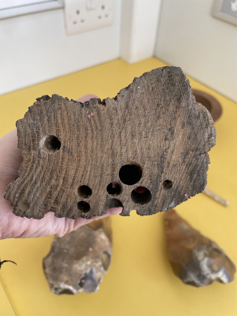
Figure 2: Holes left by shipworms – a boring organism – in a piece of timber, Maritime Archaeology Trust
How do we manage and protect our maritime archaeology?
Excavation preserves part of the archaeological remains off site. This is what we see in a museum, and is a vital part of education and awareness of maritime archaeology. In some cases, excavation may be the only option to rescue the remains; for example, the retrieval of parts of the Swash Channel Wreck off Poole Harbour was the only viable option as the ship was succumbing to shipworm degradation. Under the 2001 UNESCO Convention of the Protection of Underwater Cultural Heritage, excavation must follow the rules of good practice including proper treatment of artefacts (Manders, 2008). Excavated archaeological wood has to be treated specially to avoid degradation in an open air environment (Ruben Duque, 2011). Excavation can be combined with gathering information to assess the viability for in situ preservation of the remainder, such as the case with the Rooswijk (Beattie-Edwards, 2018).
In situ preservation mainly seeks to rebury, stabilise sediment, and create a protective shield to the environment and the anaerobic deterioration processes discussed earlier. This includes physically covering, or excavating, and redepositing/reburying the archaeological items in an environment less at risk from degradation (Gregory & Manders, 2015). Sandbags, or layers of sand, are commonly used to cover the site, but can be labour intensive. Entrapping sediment by creating an artificial seabed using artificial seagrass, shade/fabric cloth or debris/wind netting promotes sediment deposition and stabilisation (UNESCO, 2021; Gregory & Manders, 2015). However, sediment may still be removed during storms. Metal nets and cage protection is more often used to protect sites from looting (UNESCO, 2021). As such, in situ preservation methods are often under trial. Geotextile mats covered with seaweed and held down by sandbags are being trialled to protect the HMS Collossus shipwreck off the Isles of Scilly. Artefacts of the shipwreck have also been reburied after initial recording, again on a trial basis (Meara, 2020).
There is a fine balance in evaluating whether to preserve a representative part of underwater archaeology for future enjoyment and research, or excavation of artefacts for current use. In situ preservation has not always been viewed as the best way to promote underwater cultural heritage to the public, as excavated artefacts can be physically viewed and appreciated (Manders, 2008). Public interest promotes funding opportunities, which is key to any recovery/rescue or monitoring of underwater heritage. The availability of trained specialists, ongoing monitoring capacity, and existing effective knowledge of how to effectively protect sites are other important factors affecting the effectiveness of site assessment and protection (Ruben Duque 2011; Manders, 2008).
Complementary solutions to promote maritime heritage can include the creation of underwater trails and site visits in less archaeologically valuable sites (thus preserving more valuable ones) (Manders, 2008). Interactive digital displays in the form of 3D or holographic imagery – e.g. the Yarmouth Roads wreck – can provide accessible, approachable ways for the public to relate to sites of historical value (Manders, 2008).
How science helps management
To help us decide how best to manage and protect maritime archaeology, science offers numerous tools to explore what it is we are trying to protect, and how it is changing over time. Initial site surveying and ongoing monitoring often adopt the same tools. The installation of monitoring points across the sites of the Flower of Ugie, allows observation of structural remains and their exposure to the elements. Various methods of marine survey are used primarily to explore seabed topography, what the seabed is made up of, and what is lying on it (the wreck, artefacts etc.). Surveys will use sonar survey and magnetometer survey (to detect anomalies such as buried features), and positional and navigational data (Archaeology Data Source, 2024; Gregory & Manders, 2015). Automatic and on site diver held tools assess the specific environment and archaeological artefacts, and are complemented with laboratory sampling of sediments. In water methods commonly include high-resolution camera recording of the sites; the overlapping images create a detailed 3D model, which we call photogrammetry (Gregory & Manders, 2015). Distance measurements can show any migration of artefacts over time. Open water data loggers measure water salinity, dissolved oxygen, temperature, depth and current water data. Wood in low oxygen conditions, for example, supports fewer boring organisms. Water speed measurements could indicate whether a sediment entrapment method is effective in slowing current flow, and hence encouraging deposition (Gregory & Manders, 2015). Chemicals released by decaying iron for example, can provide data on how, and how fast the items are being eroded (Ruben Duque, 2011).
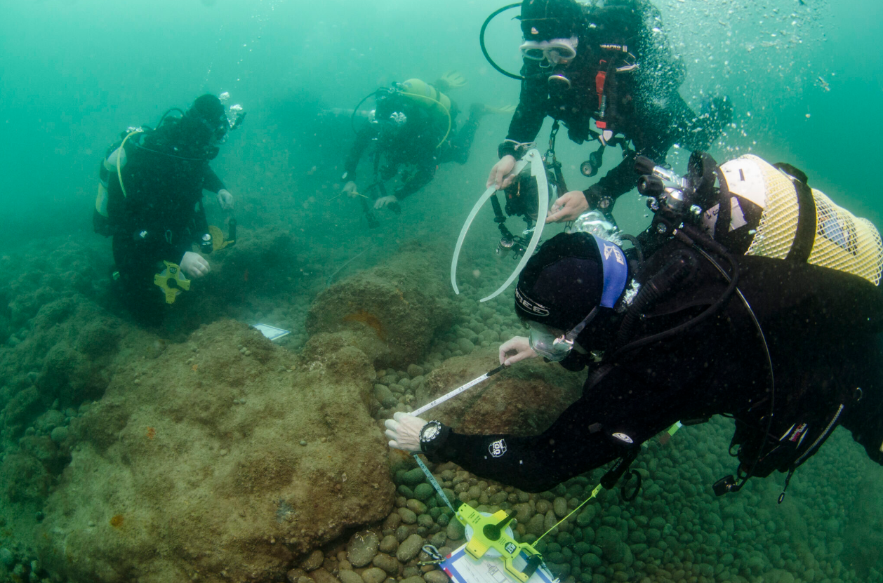
Figure 3: Water surveying at the Chesil Beach Cannon Site, Maritime Archaeology Trust
To assess the methods and feasibility for in situ preservation, further information on the durability of archaeological wood to degradation is essential (Gregory & Manders, 2015). Sediment coring provides samples of sediment at different depths to measure sediment porosity (coarser sediment types have lower rates of organic material turnover, and provide better preservation conditions) (Gregory & Manders, 2015). Coring can also measure the age of trapped seawater inside the sediment, providing an indicator of sediment stability (Ruben Duque, 2011). Dissolved oxygen, hydrogen sulphide, and carbon dioxide levels in sediment can also indicate the presence of degrading organisms. Excavation and rescue recovery has complemented palaeoenvironmental analysis and radiocarbon dating of sediments, to provide detailed site erosion analysis at Bouldnor Cliff.
Overriding any management and protection methods, is the careful consideration of the aims and goals of any excavation or in situ preservation – what are we protecting, how much of it are we protecting, and for how long? (Gregory & Matthieson, 2011). There is a balance of costs, effort of protective measures and importance of sites (Manders 2008). Management can also provide opportunities for international collaboration, and encourage public participation such as volunteer divers, such as the Dutch and English cooperation, which led to the expansion of the protected area around the Rooswijk (Beattie-Edwards, 2018).