Find out more:
- Hamble River Archaeology
- Hamble River Activity Booklet
- Archaeology of the Hamble River Leaflet
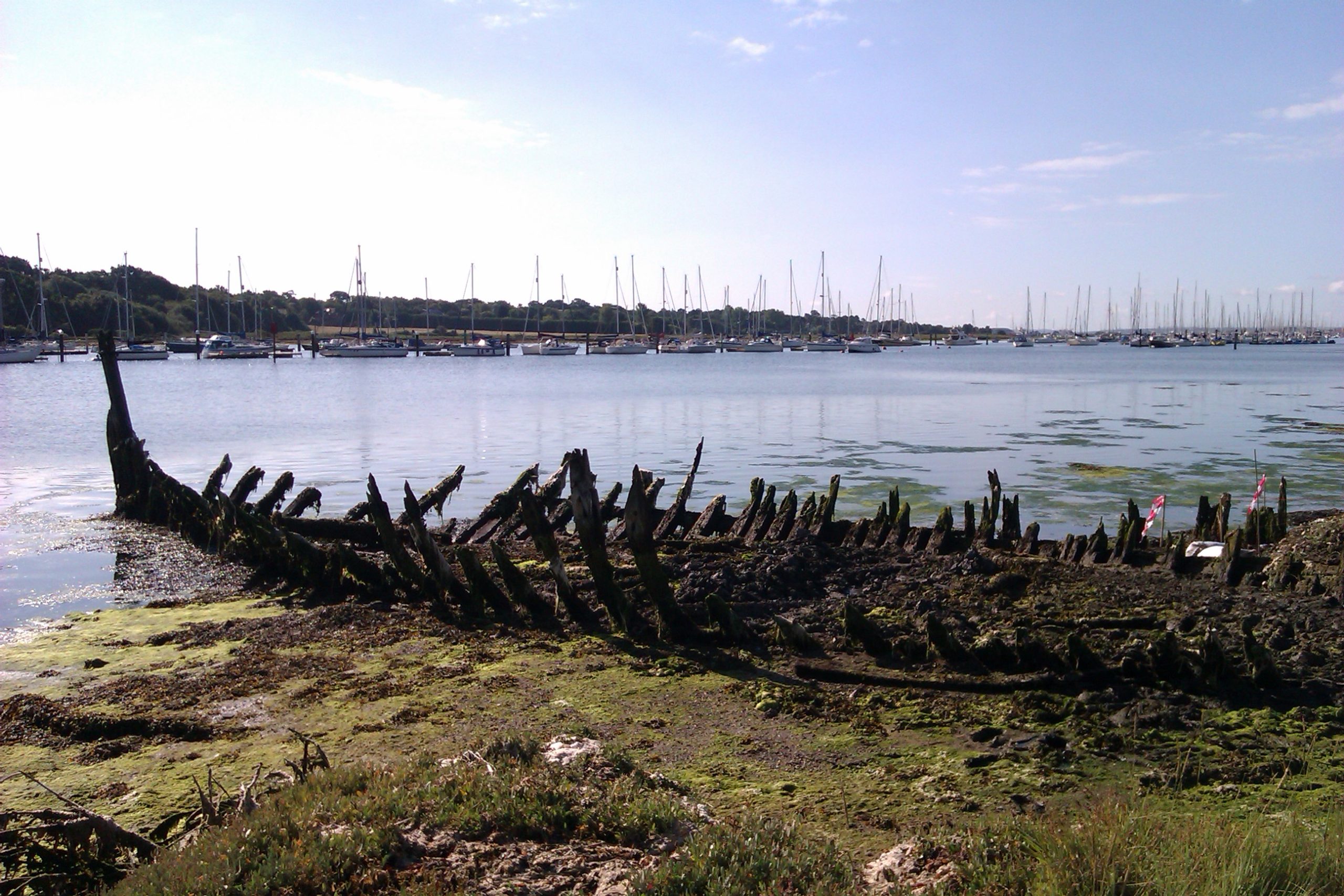
Trust volunteer Richard Wyatt, has produced this excellent series of short audio guides/podcasts to be enjoyed as you walk along the River Hamble. The files can be freely downloaded (see below) and listened to on an MP3 player. Richard’s commentary, with occasional snippets from Trust staff, provides fascinating insights into the history of the area and tells the story behind some of the vessels that have been abandoned on the River Hamble’s foreshore.
Part 1: Bursledon to Manor Farm Country Park
Walk Start
The walk starts at Bursledon Station, which has a free car park. If you are arriving by bus (FirstBus services 4, 4A and X4 between Southampton and Fareham/Gosport pass along the main road) there is a stop at Blundell Lane; just walk up the lane until you are away from the traffic noise.
Walk description
The walk is flat and follows the edge of the river. From Bursledon to the motorway, it follows a surfaced road. There are then two stiles followed by a walk across a field, then another stile before entering Manor Farm Country Park. The designed walk has one steep section at the end. If you plan on walking further within the park, the paths are well-maintained but steep in places. At a normal walking pace, it should take you about 45 minutes, including listening to the commentary. There are 8 commentary points on the route, varying from 1 minute to 5 ½ minutes. Each piece of commentary ends with concise instructions on how to get to the next point, before you play the following track.
Before you leave home
- Check on the tide times at the UK Hydrographic Office. The lower the tide, the more you can see.
- Have a look, too, at the Manor Farm website. You might decide to make a day of it.
- Pack the binoculars. There’s wildlife out there, too!
- Bring sturdy shoes. Remember that if you park a car at the station, you’ll probably be walking back, too. Parts of the walk can be muddy after heavy or prolonged rain.
- There are no shops on the route, so bring some nibbles and something to drink.
Part 2: Swanwick to Warsash
Walk Start.
The commentary starts at the benches and small green near the public slipway at Swanwick shore (Ordnance Survey Grid Reference SU 49570 09218, nearest Post Code SO31 7EF). There is very limited car parking near this spot, particularly at weekends; free parking is available at Bursledon railway station, which is about three-quarters of a mile to the west. From the station, return to the main road, then cross the bridge over the river, past the entrance to Premier marina and turn right into Swanwick Shore Road. By bus, FirstBus services 4, 4A and X4 between Southampton and Fareham pass along the main road (A27).
Walk Description:
The walk is flat and follows the edge of the river. There is however a bridge on the route, with half a dozen steps on each side. Duyring spring high tides (not the season, but the name given to tides that are higher than average), some parts of the path may be underwater, but we would always recommend you try to visit when the tide is low – many more of the wrecks are visible.
The commentaries were made on-site on a particularly windy day, so you will hear some background noises like the wind in the trees and the lapping of waves amongst others. At a normal walking pace, the walk should take about one and a quarter hours, including listening to the commentary. There are 13 listening points, totalling about 28 minutes of audio. Swanwick shore to Warsash is about two and a quarter miles.
After completing the walk, you have several options. Your chauffeur, helicopter or private yacht can pick you up from Warsash. If you left a car at Bursledon or Swanwick, you could simply retrace your steps, or take FirstBus 4 or 4A back to Lower Swanwick. But you could also take the Pink Ferry across to Hamble (it runs all year round). From there, bus number 6 can take you to Southampton. A further alternative is to use the footpaths up the western side of the river back to Bursledon. This follows part of the Strawberry Trail, which is marked on the information board near the ferry, but we’d recommend using an Ordnance Survey map to find the footpaths.