MAT has undertaken a number of projects within Chichester Harbour, often in conjunction with local organisations such as the Chichester Harbour Conservancy, Emsworth Maritime and Historical Trust (EMHT) and Chichester and District Archaeology Society (CDAS). A Heritage Lottery Funded project run by CHC between 2004-2007 delivered a number of initiatives which help develop understanding of the archaeology and wider cultural landscape of the harbour.
Projects that MAT have delivered within Chichester Harbour include:
Hayling Island Wadeway
This causeway runs from the village of Langstone southwards to Hayling Island and is severed by two channels at all but the lowest of tides. It was long thought likely to date from at least as early as the Bronze Age, when there was significant activity in the area and the Wadeway would have been the only land crossing to Hayling Island until permission was granted to build a bridge in 1817. In 1821 it was cut through by the Portsmouth to Arundel canal.
The first documentary reference to the Wadeway dates to 1552 and the toll for crossing the feature. Later references mention the costs of maintenance. The first cartographic evidence of the Wadeway is found on Taylor’s 1759 map.
A topographical survey and recording of features on the Wadeway was carried out in 2000 in conjunction with local volunteers. Ten timber structures were recorded, which appeared to provide structural support for the causeway.
A more detailed survey in 2008 included excavation work and auger surveys to analyse the composition of the structure and seek artefacts to help in dating the structure. No significant artefacts were discovered, however a combination of radio-carbon dating, palaeoenvironmental analysis and other techniques indicated that the area was terrestrial in nature until at least the Post Roman period, and the causeway is most likely to have been constructed in the 13th or 14th century AD.
The project resulted in a publication in the Proceedings of the Hampshire Field Club and Archaeology Society.
Emsworth Oyster Beds
In 2008 the MAT joined forces with the Emsworth Maritime and Historical Trust (EMHT) and Chichester and District Archaeology Society (CDAS) to work with volunteers to survey abandoned oyster beds on the Emsworth foreshore.
The project, funded by a grant from the Chichester Harbour Conservancy Sustainable Development Fund recorded the remains of several timber-lined pits on the foreshore. These were dug to store oysters for a huge oyster industry that thrived in Emsworth in the 19th and early 20th centuries. The industry collapsed in 1902 after oysters contaminated by typhoid from a new sewer in Emsworth Harbour were served at banquets at Winchester and Southampton. The oysters poisoned several people and killed the Dean of Winchester.
Volunteers were trained by the MAT and a guidance manual was created to assist them in the archaeological survey of the beds. The team recorded numerous beds, the positions of which were recorded with sufficient accuracy to identify the original pond owners from historic maps. The project culminated in a special display on the oyster industry at the Emsworth Museum that incorporated volunteers’ plans and records of the site.
Click here for a copy of the project report.
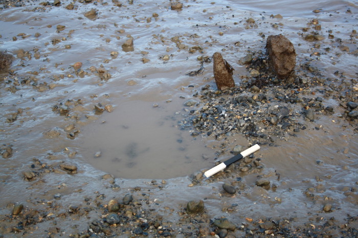
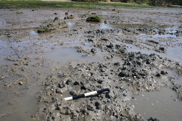
Impact of Bait Digging on Archaeology
This project developed a better understanding of the impact of bait digging on archaeological artefacts and deposits. There is a lack of understanding of the impact of this potentially damaging activity on a national scale. During previous work in Chichester Harbour at the southern end of the Wadeway disturbance from bait digging had been recorded. This had left an area heavily truncated and damaged and sediments containing archaeological material had been disturbed.
The action of bait diggers involves digging through the intertidal sediment and turning it over, which leaves a hole where the material was from and a small mound of sediment with the previously buried material now exposed on top. As fine sediments are washed from the top of the mound of material it often leaves artefacts exposed. At the southern end of the Wadeway there were worked and burnt flint frequently seen on these bait digging mounds.
There is a need to further examine the impact of bait digging on intertidal deposits in relation to the historic environment in order to best manage heritage assets and bait digging activity. As there had been recorded issues with bait digging in Chichester Harbour this provided the opportunity to undertake a pilot study that would not only benefit the management of the AONB, but would also act as a demonstration project on a national basis.
This project has was funded by the Chichester Harbour Sustainable Development Fund. Two seasons of fieldwork were carried out, the first in June 2014 and the second in January 2015, this allowed us to assess change over time and potential damage from bait digging at different times of the season. This involved a survey of sites containing known archaeological features which are also known to be impacted by bait digging activity. Four areas were selected, The Wadeway. Prinsted, Chidham and Dell Quay to Copperas Point.
The results of the fieldwork are available in this report.
Hulk Survey
The foreshore of the Harbour contains the abandoned remains of ships and boats. These vessels can range from substantially intact relatively modern craft, to only the keel and ribs just protruding from the mud. Other craft may lie totally buried within sediment. The MAT investigated:
- A group of abandoned vessels north of Dell Quay which represent a variety of craft types.
- A group of landing craft type vessels to the east of Hayling Island, in the Emsworth Channel.
During April 2004, the MAT undertook a survey of four hulks on behalf of the Chichester Harbour Conservancy. These vessels were due to be removed as part of the Lottery Funded Project which focused on a number of environmental projects around the harbour. A photographic and drawn record of the vessels was completed and preliminary research into their history and origin carried out. The photographic and drawn record of one of the vessels, a Pinnace or tender, can be viewed as a pdf (436kb)
Intertidal Structures Survey
A desk based assessment of foreshore structures around the harbour identified 33 sites that might help understand the changing nature of the harbour particularly in the post-medieval period. These sites were surveyed – they included groynes, sea walls, causeways, oyster bed and farming remains, salt production, and maritime transport related structures such as wharves, jetties, landing places.
More details are available from the Chichester Harbour Conservancy website.