Aids for mariners are essential for safety at sea and nowadays are commonplace. Charts are now mostly accurate except where sandbank positions, for example, are transient due to tidal wave action. Satellites provide accurate locational information for ships on the open sea. But before modern technology, and still to this day, lighthouses and lightvessels play an essential part. Volunteer Roger Burns looks briefly at their early history, then explores in more detail those Lightvessels which were and are located in the English Channel within the area of interest defined by MAT’s Forgotten Wrecks Project. Some lightvessels were used only in wartime. Originally referred to as lightships, all references are now to lightvessels.
A brief history of Lighthouses and Lightvessels
Ancient practice was geared to using beacon fires on hilltops or fires atop modest structures placed to guide mariners into ports rather than avoidance of reefs. There is some uncertainty about the first lighthouse in the world, but the first verified lighthouse was built about 280BC at Alexandria in Egypt, with a fire on top of a 350ft. (c.107m) high structure, reputedly the highest ever built.
Lightvessels followed later, the first in UK being in 1790 when a business partnership of Robert Hamblin, formerly a barber, and David Amery, a ship manager from King’s Lynn, secured a government licence to moor a manned ship with a prominent light to serve as a navigation aid at the Nore, at the mouth of the River Thames, Figure 1. However, Trinity House who were established in 1514 for the Maintenance of Lighthouses and Beacons objected, the above licence was revoked in 1734 and Trinity House assumed responsibility. More lightvessels followed, several have been discontinued or replaced by lighthouses. Current lighthouses and lightvessels are enumerated below in Figure 7.

Figure 1: First Lightvessel at the Nore
Source: William Lionel Wyllie, Public domain, via Wikimedia Commons
Vessels Overview
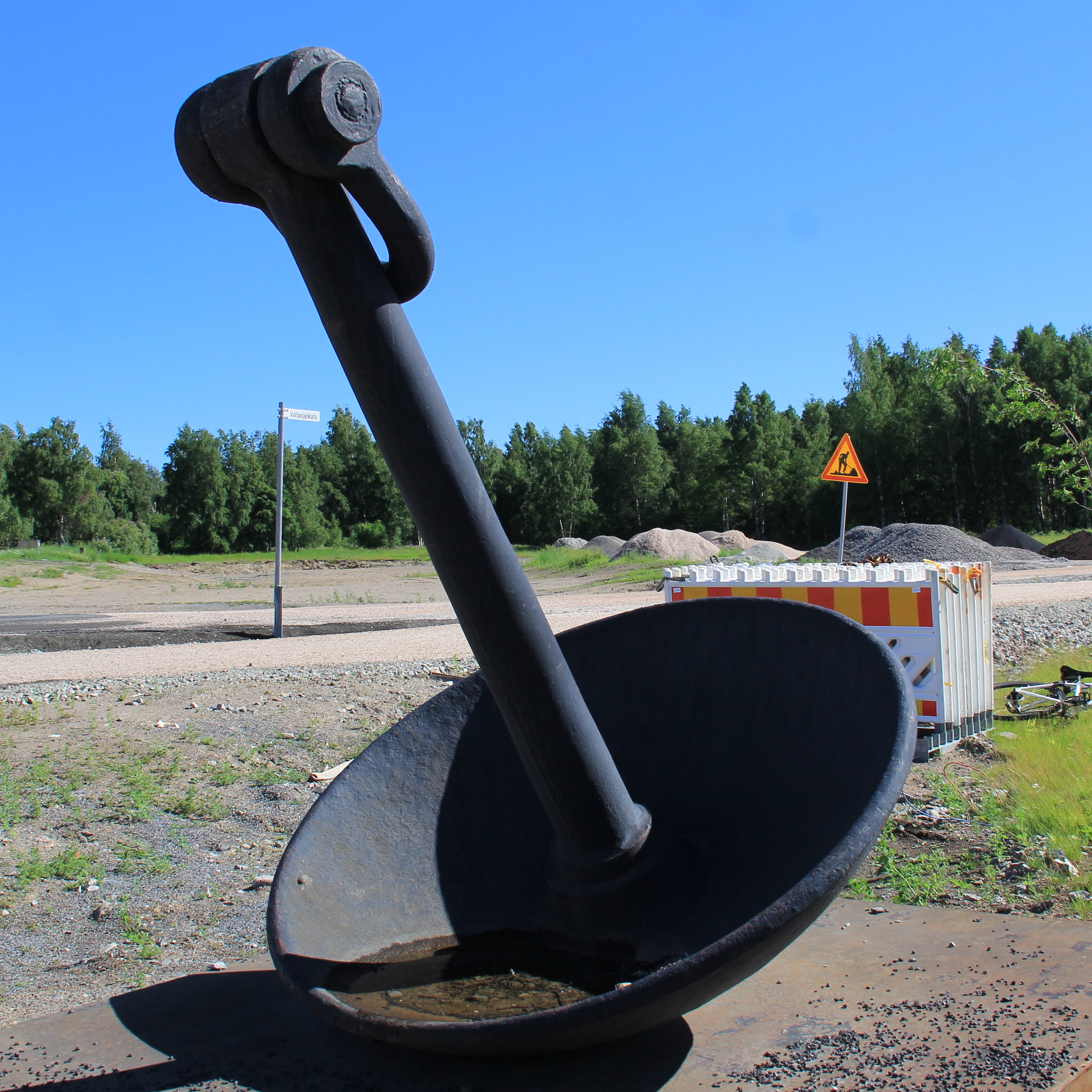
Lightvessels were originally wooden hulled, becoming iron and then steel hulled, functionally purposed with a tower amidships for a powerful light, and originally with accommodation for the crew although now mostly unmanned and automated using solar power. British lightvessels are typically single deck, less than 33m in length, without propulsion, thus require to be towed when needed. Generally allocated a number, LVxx, vessels are painted red for good daylight recognition, with the name of the posted station in large white letters, changed when moved to a new station. Robust anchoring is paramount, and initially fluke anchors, Figure 2, were used but prone to dragging, were changed in early 19th century to mushroom anchors, Figure 3, weighing 3-4 tons.
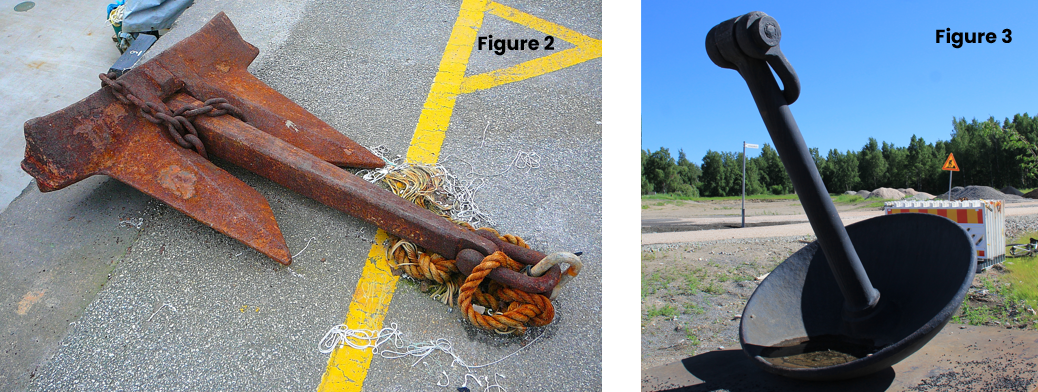
Figure 2: Anchor with two flukes, Source: Tim Green from Bradford, CC BY 2.0, via Wikimedia Commons
.jpg)
Figure 3: Mushroom anchor, Source: Htm, CC BY-SA 4.0, via Wikimedia Commons
Lightvessels within the Area of Interest and now removed or replaced

Table 1: Key showing location name of Lightvessels for Figures 4 and 5
These Lightvessels are shown in Figures 4 & 5 including some current Lighthouses and/or Lightvessels which are fully detailed in Figure 7.
Calshot Spit – Until decommissioned in 1987, LV 78 was stationed off Calshot Spit, Figure 4 key F1, to guide ships and flying boats entering Southampton Water. Built in 1914 by John I. Thornycroft in Southampton, it was an attraction in Ocean Village from 1988 until 2010 and is now at Solent Sky museum and on the National Historic Ships UK register.
Nab – Replaced in September 1920 by a lighthouse, Figure 4 key F2, the Nab lightvessel was active from 24 September 1812 as announced in the Public Ledger and Daily Advertiser of 29 September. Referred to then as a Floating Light near the Nab Buoy, the newspaper gave extensive details of bearings from other landmarks, stated that there were two Lanthorns suspended from two masts 43 ft (c. 13.1m) apart, at 18ft (c.5.48m) and 25ft (c.7.62m) above the deck and be reasonably distinguished from the Owers Floating Light and other Lights in the vicinity.

Figure 4: Former Lightvessels F1, F2 and F3
Source: Maritime Archaeology Trust
Owers – Operational from 1788, Figure 4 key F3, one of the vessels stationed here was LV 15 built in 1839, sold in the late 1920s. For another lightvessel stationed here, the RNLI lifeboat Canadian Pacific was tasked late at night on 17 July 1950 to take a doctor to the lightvessel as its master had suspected appendicitis. The master was taken off and then to the West Sussex Hospital. In 1971, this lightvessel was used to study waves in the English Channel, and in 1993 the then current lightvessel was replaced by a beacon.
Royal Sovereign – Operational from 1875 located seven miles from Bexhill on the Royal Sovereign shoals, the lightvessel was of steel and timber composite construction. Figure 5 key F4, it was the first to have a flashing light, three successive flashes at one-minute intervals, changed in 1877 to three quick flashes every 45 seconds. Again, RNLI were called to assist with an ill crew member. A lighthouse relaced the vessel in 1971, automated in 1994, and was deactivated in 2022.

Figure 5: Former Lightvessels F4 to F9
Maritime Archaeology Trust
South Folkestone Gate and North Folkestone Gate – During the First World War, these two lightvessels, Figure 5 key 5 & 6, were stationed off Folkestone to mark a gap in the extensive minefields, as shown here (post1) which also depicts North, East and South Goodwin lightvessels. At the end of the war, North Folkestone Gate vessel was discontinued, and its southern counterpart, which was the Varne lightvessel prior to the war, relocated 2¼ miles north-eastwards. In the Second World War, the Folkestone Gate vessel was bombed and sunk.
Gull Steam – Also called Gull, it was stationed between the Goodwin Sands and the mainland during the First World War, Figure 5 key F7. Built as LV38 in 1860, this wooden hulled vessel served elsewhere and then by the Goodwin Sands from 1929 for one year when it was sunk from a collision, refloated, renamed Brake and placed at Brake Sand on the Goodwin Sands. After another collision in 1940 at Brake Sand, it was removed, repaired, and sent to Mouse Station in the mouth of the river Thames and renamed Mouse. Attacked by enemy aircraft fire in 1941 it was laid up, then postwar, Grays Yacht Club bought it to use as a club house at Thurrock until the 1970s when a permanent club house was built. It then became redundant and hulked beside the River Thames until at least 2007.
Goodwin Sands – With only East Goodwin remaining today, originally five lightvessels were placed at the Sands, a complex stretch of water, recognised as such in 1750 as indicated in Figure 6, and which were notorious for some 2,000 wrecks including the Stirling Castle.
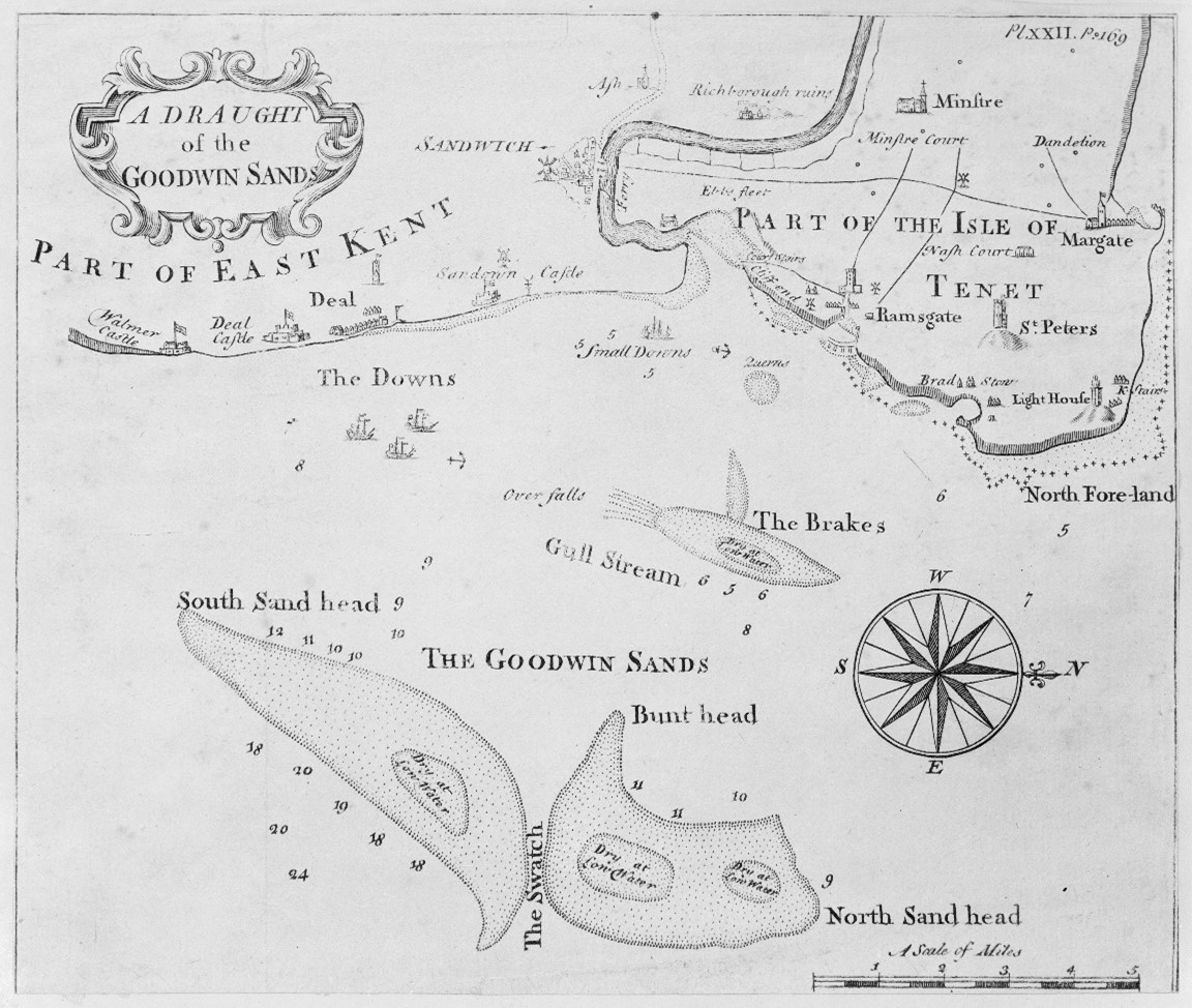
Figure 6: The Goodwin Sands in 1750
Source: From Royal Museums Greenwich, Public domain, via Wikimedia Commons
The Isle of Tenet, now Thanet, is shown separate from the mainland by the Wantsum Channel but is now joined.
North and South Goodwin Lightships – The sands were once covered by three lighthouses on the Kent mainland with only North Foreland lighthouse still in operation. South Foreland lighthouse, formerly South Foreland Upper lighthouse, now owned by the National Trust, once worked with the nearby South Foreland Low lighthouse, also known as Old St Margaret’s Lighthouse. If the two South Foreland lights were in alignment, ships’ crews would know that they had reached the South-most extent of the sandbank. When the Goodwin sands shifted, South Foreland Low was decommissioned, replaced by the South Goodwin Lightvessel, Figure 6 key F9. The first of these ships was bombed by the Germans and sank on 25 October 1940. The replacement vessel, LV90 sank on 27 November 1954, when cables to her two sea anchors broke in a hurricane-force storm and it was the first Trinity House ship to be lost in this manner. The wreck of the lightship can still be seen at low tide. The final South Goodwin Lightvessel was decommissioned and removed on 26 July 2006. The North Goodwin, Figure 6 key F8, was first stationed in 1795 and was removed in April 1988.
Current Lighthouses and Lightvessels within the Area of Interest
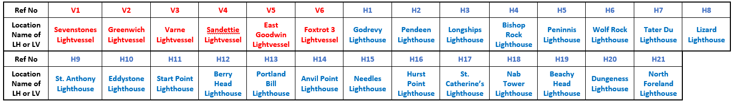
Table 2: Key showing location Name of LH or LV in Figure 7
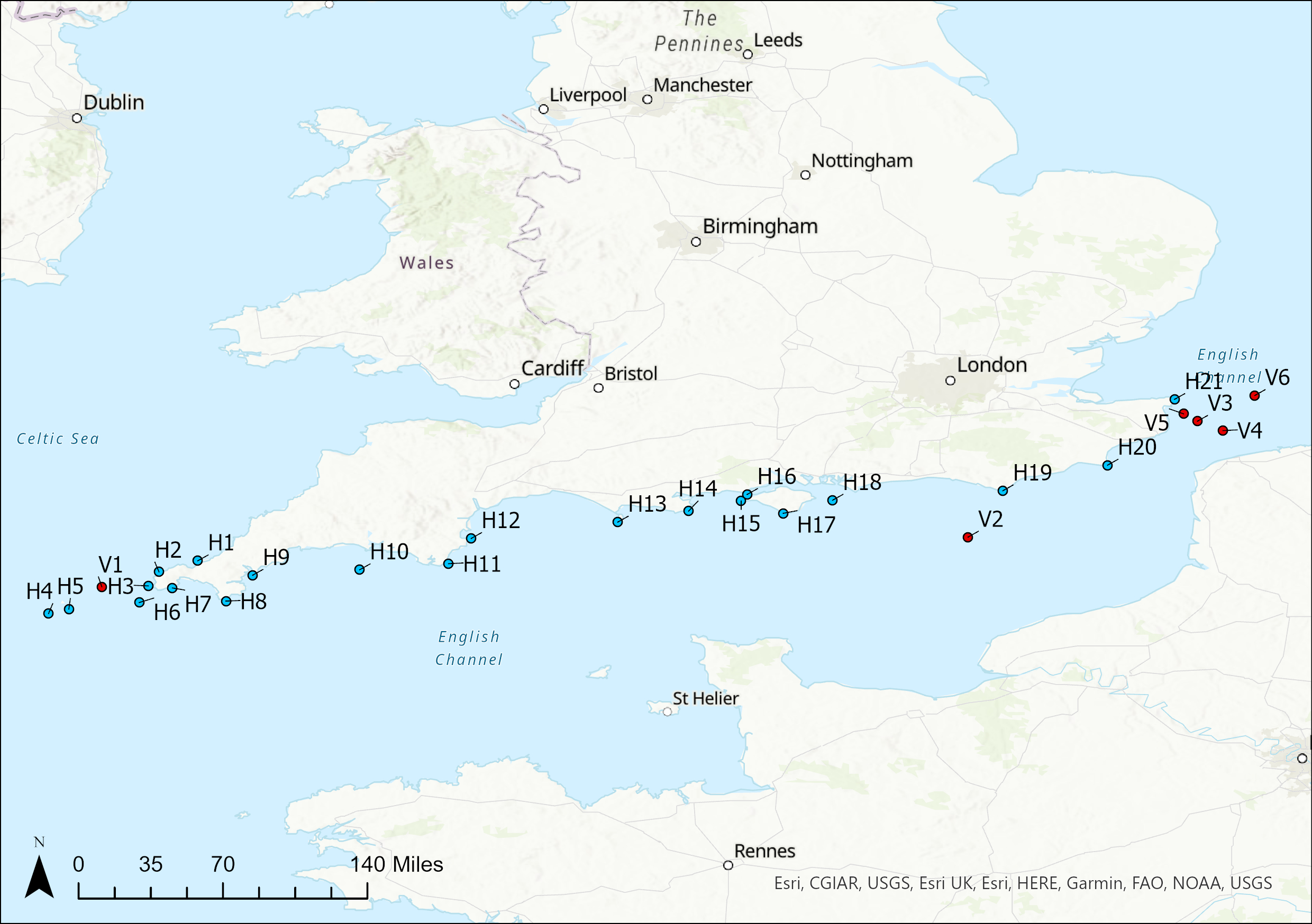
Figure 7 : Current Dispositions of Lighthouses and Lightvessels along the English South Coast
Source: Maritime Archaeology Trust
Sevenstones Lightvessel – This lightvessel marks and is about 4km NE of the Sevenstones rocks which is a dangerous reef about 24km WNW of Land’s End. A hazard for centuries, and the source of an estimated 200 shipwrecks, including the infamous oil tanker Torrey Canyon. The rocks are submerged for much of the tidal cycle, and unsuitable for a lighthouse. The first of six lightvessels at Sevenstones was commissioned on 1 September 1841. It broke free several times; it is now an automated weather station and a detailed history is provided here.
Greenwich Lightvessel – Established in 1995, the LV5 built 1946 is now solar powered.
Varne Lightvessel – Established 1860, the lightvessels here were involved in an incident with LV95 in 1966 and again in 1981 involving LV21.
East Goodwin Lightvessel – Established 1874, it guards the northern end of the Sands and three incidents are of note. The first in 1899 involves Guglielmo Marconi as related here and here. The second was when lost in 1940, and the third in 1961 was when it broke free of its moorings.
Foxtrot 3 Lightvessel – Established 1972, it is stationed at the eastern end of the area of interest.
Sandettie Lightvessel – A French 1949 built vessel served here until 1989 marking the Sandettie bank when it was replaced the same year by a Trinity House lightvessel.