We have lots of exciting audio content to explore, from audio-guided walks to shipwreck stories.
This guided walk podcast explores the coastal path between Newtown and Whale Chine on the Isle of Wight. Scroll down to see all of the individual audio tracks.
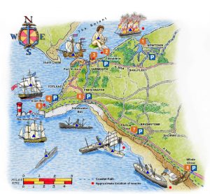
Directions
1. Newtown
Public pathway: The Coastal Path
Directions: You get the best view over the estuary by walking out to the end of the boardwalk. Follow Public Footpath sign CB9 from the village centre past the church towards the harbour.
2. Bouldnor Cliff
Public pathway: The Coastal Path.
Directions: The Coastal Path takes you through Bouldnor Forest where you can view the bay.
3. Yarmouth
Public footpath: The Coastal Path.
Directions: The site can be seen from anywhere in the park to the east of Yarmouth; follow the Coastal Path east from Yarmouth or west from Newtown.
4. Alum Bay
Public footpath: The Coastal Path.
Directions: If there is an opportunity, climb or take the chair lift (external link) down to the bay. If not, view the site from the talking telescope platform.
5. The Needles
Public footpath: The Coastal Path.
Directions: The best place to appreciate The Needles is from the viewpoint next to The Needles New Battery (external link) and Rocket Testing Site.
6. Freshwater Bay
Public footpath: Coastal Path.
Directions: The Coastal Path goes past Freshwater Bay. Pause here to enjoy the view over the bay.
7. Chilton Chine
Public footpath: The Coastal Path.
Directions: At Chilton Chine the Coastal Path goes inland around the car park. Take the opportunity to look out to sea before the path briefly leaves the coast.
8. Whale Chine
Public footpath: The Coastal Path.
Directions: Follow the Coastal Path around Whale Chine. The best viewpoint is on the east side of the cliff.
Trust volunteer Richard Wyatt, has produced this excellent series of short audio guides/podcasts to be enjoyed as you walk along the River Hamble. The files can be freely downloaded (see below) and listened to on an MP3 player. Richard’s commentary, with occasional snippets from Trust staff, provides fascinating insights into the history of the area and tells the story behind some of the vessels that have been abandoned on the River Hamble’s foreshore.
Part 1: Bursledon to Manor Farm Country Park
Walk Start
The walk starts at Bursledon Station, which has a free car park. If you are arriving by bus (FirstBus services 4, 4A and X4 between Southampton and Fareham/Gosport pass along the main road) there is a stop at Blundell Lane; just walk up the lane until you are away from the traffic noise.
Walk description
The walk is flat and follows the edge of the river. From Bursledon to the motorway, it follows a surfaced road. There are then two stiles followed by a walk across a field, then another stile before entering Manor Farm Country Park. The designed walk has one steep section at the end. If you plan on walking further within the park, the paths are well-maintained but steep in places. At a normal walking pace, it should take you about 45 minutes, including listening to the commentary. There are 8 commentary points on the route, varying from 1 minute to 5 ½ minutes. Each piece of commentary ends with concise instructions on how to get to the next point, before you play the following track.
Before you leave home
- Check on the tide times at the UK Hydrographic Office. The lower the tide, the more you can see.
- Have a look, too, at the Manor Farm website. You might decide to make a day of it.
- Pack the binoculars. There’s wildlife out there, too!
- Bring sturdy shoes. Remember that if you park a car at the station, you’ll probably be walking back, too. Parts of the walk can be muddy after heavy or prolonged rain.
- There are no shops on the route, so bring some nibbles and something to drink.
Part 2: Swanwick to Warsash
Walk Start.
The commentary starts at the benches and small green near the public slipway at Swanwick shore (Ordnance Survey Grid Reference SU 49570 09218, nearest Post Code SO31 7EF). There is very limited car parking near this spot, particularly at weekends; free parking is available at Bursledon railway station, which is about three-quarters of a mile to the west. From the station, return to the main road, then cross the bridge over the river, past the entrance to Premier marina and turn right into Swanwick Shore Road. By bus, FirstBus services 4, 4A and X4 between Southampton and Fareham pass along the main road (A27).
Walk Description:
The walk is flat and follows the edge of the river. There is however a bridge on the route, with half a dozen steps on each side. Duyring spring high tides (not the season, but the name given to tides that are higher than average), some parts of the path may be underwater, but we would always recommend you try to visit when the tide is low – many more of the wrecks are visible.
The commentaries were made on-site on a particularly windy day, so you will hear some background noises like the wind in the trees and the lapping of waves amongst others. At a normal walking pace, the walk should take about one and a quarter hours, including listening to the commentary. There are 13 listening points, totalling about 28 minutes of audio. Swanwick shore to Warsash is about two and a quarter miles.
After completing the walk, you have several options. Your chauffeur, helicopter or private yacht can pick you up from Warsash. If you left a car at Bursledon or Swanwick, you could simply retrace your steps, or take FirstBus 4 or 4A back to Lower Swanwick. But you could also take the Pink Ferry across to Hamble (it runs all year round). From there, bus number 6 can take you to Southampton. A further alternative is to use the footpaths up the western side of the river back to Bursledon. This follows part of the Strawberry Trail, which is marked on the information board near the ferry, but we’d recommend using an Ordnance Survey map to find the footpaths.
These audio articles were recorded as part of the Forgotten Wrecks of the First World War project for Talking Newspapers.
There are more than 500 local Talking Newspapers in the UK. They provide audio recordings (in a variety of formats) of local newspapers that are read out loud, recorded and edited by volunteers. The typical audience for Talking Newspapers is blind or partially sighted people.
The Forgotten Wrecks project worked with the Talking News Federation to create and distribute audio articles about the Forgotten Wrecks project for use by local Talking Newspapers around the country. The articles are available to listen to below.
We are very grateful to Chris Litton and the Southampton Area Talking News for their support in the production of some of our Audio Articles. They have kindly provided facilities, knowledge, skills and time, enabling us to improve the quality of these audio articles.
You can find the text for these articles and other wreck stories here.
The following audio was created as part of the Fathoming The Future project, researched by Rory Gudgeon and read by Greta Clarke. Telling the story of the SS Serrana, which was included on the Forgotten Wrecks database.
This audio file was created as part of the Fathoming The Future project, researched and read by volunteer Shirley Wilson and recorded at the Southampton Talking News studio.
The topic of ‘lascar’ sailors was first explored in the Trust’s podcast ‘Uncharted Maritime Tales, Episode 1: The Camberwell‘. Having explored who these men were, Shirley now delves further into the artefacts and monuments that tell their story.
Have you ever thought about how your parents, grandparents or even great-grandparents coped with rationing during the Second World War? Or how much pay and holiday entitlement they recieved? This podcast provides some fascinating insights into the social history of the war.
D-Day, the Allied invasion of Normandy, was a significant part of the Allied liberation of Europe and the end of the second World War. This podcast has interviews with people who were there at the time and gives eye witness accounts from two different perspectives.
The podcast also has interviews and excerpts discussing differences between pay, holiday, and food now and during the Second World War.
This podcast uses audio clips recorded during the previous MAT project, Dive Onto Victory, commissioned to commemorate the 200th anniversary of the battle of Trafalgar. Between 2005 and 2007 the Trust dive team investigated a number of sites within Portsmouth Harbour. One site in particular, on the Gosport side of the Harbour, proved to be significant and, after survey, around 250 artefacts were recovered from the seabed. In addition to the archaeological investigations, the project also sought to collect oral histories related to working on or with the sea. For more information, go to Dive onto Victory.
Another MAT project that may be of interest is the Landing Craft project, funded by English Heritage. This project enabled collaborative work between the MAT and Southsea Sub-Aqua Club to survey and record the remains of LCT(A) 2428, a Second World War landing craft that sank in the eastern Solent in June 1944. For more information, go to the Landing Craft project.
The Preparation for D-Day in Southampton
But what about the logistics that goes into planning an invasion?
Well, for this collection of audio segments, volunteer Maggie Fogg shares the transformation Southampton went under to prepare for the monumental amphibious invasion known as D-Day. Listen to learn more about how thousands of men were trained, homed and finally shipped over to Normandy for the liberation of Europe. Learn about how Southampton’s commons and schools were commandeered for planning the attack, and how the docks played such a pivotal role in transporting landing craft and mulberry harbours to Normandy. The audio was researched by Maggie herself as part of the trust’s new Fathoming The Future project, made possible by the National Lottery Heritage Fund.
On the evening of the 5th June 1944, while on passage to Normandy, LCT(A) 2428 experienced engine trouble. Although taken under tow by the rescue tug HMS Jaunty, the landing craft capsized and lost its cargo of Centaur tanks. HMS Jaunty fired upon the upturned hull until it sank, in order to remove a potential navigational hazard for other vessels in the invasion fleet. None of the crew or passengers of LCT(A) 2428 were lost.
The manner of loss of LCT(A) 2428 created two sites on the seabed. The first site, at the point of capsize, consists of the vehicles and other equipment that was being carried on board at the time. The second site comprises the upturned hull of the landing craft.
You can read more about the project here.
Following the Maritime Archaeology Trust’s (MAT) successful Forgotten Wrecks of the First World War project, the Friends of the Maritime Archaeology Trust, with the help of the National Lottery Heritage Fund, used outputs from the project to help more people learn about their heritage through the Shipwrecks for the Senses project. One of the projects objectives was to engage with groups that have issues with varying degrees of deafness, blindness, and the elderly who can find everyday access to this information difficult.
These audio articles were used as part of the sessions, and relate to the wrecking of the Eleanor during the First World War.