Vessel History
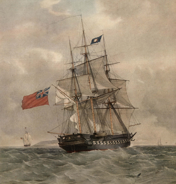
HMS Pomone was a 38-gun 5th rate Leda-class frigate, built for the Royal Navy in 1805. The ship initially operated in the English Channel and captured a number of Spanish and French vessels in the following years. In 1808, Pomone was posted to the Mediterranean under the command of Captain Robert Barrie, where it was involved in a number of actions against French vessels.

In October 1811, the ship was returning from Istanbul, or Constantinople as it then was, bound for Portsmouth. On board was Sir Harford Jones, the retiring British Ambassador to Persia and several Arab stallions, a gift from the Shah of Persia to King George III. It was also carrying some urgent dispatches, picked up in en route, believed to contain information about an uprising against Napoleon in Sardinia. This is probably why the Captain decided to take a shortcut, rather than approaching Portsmouth via the east of the Island. Unfortunately in the fading light and October mist, the ship’s master mistook the lighthouse at The Needles for the light at Hurst Castle, on the north side of the Solent. Captain Barrie’s intervention with the faulty navigation came too late and the ship hit Goose Rock at the western end of The Needles and was left rudderless and severely holed, stranded on rocks. Fearing the worst, some of the crew broke into the spirit casks and drank themselves senseless; one was later sentenced to 50 lashes, but pardoned because of his previous good record.
Fortunately there was no wind that night, and boats from the guard ship Tisiphone and pilot boats from Yarmouth were able to get alongside within an hour. They managed to take off all 283 officers and crew, and the passengers. Over the next three days Pomone‘s cannon, masts, cargo and valuables were all salvaged, with the Shah’s horses being brought out through the gun ports. Subsequently, in response to the wrecking, the Admiralty ordered that its ships should not attempt the Needles Passage at night.
Site Overview
The main wreck site of the Pomone is situated on the Needles within the designated Protected area. Archaeological investigations here were undertaken in the 1980s and into the 1990s, details of this work can be found here:
- D Tomalin, P Simpson & J Bingeman ‘Excavation versus sustainability in situ: a conclusion on 25 years of archaeological investigations at Goose Rock, a designated historic wreck-site at the Needles, Isle of Wight’ in International Journal for Nautical Archaeology Volume 29 No1
The identification of a substantial piece of wooden wreckage in Alum Bay as being part of the hull structure of HMS Pomone began back in the early 1990s. This wreck, for many years was known as the Alum Bay 1 wreck. This site is explored in depth here, with full analysis being available in the publication: The Maritime Archaeology of Alum Bay (MAT Monograph Series No. 2).
The section of Pomone’s hull in Alum Bay lies in 7-8m of water and at their maximum extent these remains measure c.18.5m in length with a width of 8m and lie in a generally north/south alignment. The majority of the structural remains are wooden elements that formerly comprised the framing and planking of the of the upper elements from the port-side bow area of the vessel.
Iron hull reinforcement elements are also present across the structure and two types of identifiable fastening material survive in-situ; wooden treenails and copper bolts. Outer hull sheathing in the form of fragmentary thin sheets of copper has also been recorded and recovered from the site and this carries the broad arrow stamp of the Royal Navy. Additionally, evidence for the provision of gunports on the vessel also survive, indicating an armed vessel. Finally, at the northern end of the site the remains of a pair of lead anchor hawse-holes are preserved indicating that the bow of the original vessel was towards the north. All of these features and characteristics were sufficient to confirm the remains as part of HMS Pomone.
Alum Bay also contains another, as yet unidentified wreck, known as the Alum Bay 2 wreck.
Investigations
During 1993 and 1994 an initial survey was carried out, establishing datum points and producing a basic scale plan of the site. The wreck was monitored in the years after the first plan was completed and returned to for further survey in 1998. Over the next two seasons a new plan of the wreckage was produced; this served as a monitoring tool to compare to the 1994 plan. There had clearly been considerable changes over the intervening years partly due to anchors being dragged through the site and dislodging elements. The surrounding sediments were also subject to change and varying amounts of structure were visible between seasons.
Work continued to survey the extent of the site and in particular to record the detail of the timber, the iron reinforcement pieces and the copper fastening. This work was completed for the first time in 1999 when the detail of the structural remains was plotted, along with all of the datum points that had been established on the site and which served to locate the timber recording.
In 2000 excavation was undertaken at the north and south extremes of the site. The aim of this was to assess whether the full extent of the site had been realised and to investigate the condition of any buried structure. The results showed that there is only a thin covering of sediment over most of the site and that intact timber planking remains below; the coherent structure extends only a few metres further than the visible elements. Areas excavated were reburied with sediment at the end of the project.
At this stage in the work only a limited number of finds, which were under immediate threat, had been raised from the site. The most numerous of these artefacts were the large copper bolts that were originally used to fasten the frames of the vessel together. Some of these bolts have broad arrows stamped on them, indicating that the remains probably represent a Royal Navy ship. Broad arrows were stamped on copper belonging to the Navy to discourage theft from the dockyard. A piece of copper sheathing from the underside of one of the large timbers near the northern end of the wreck was raised and also found to have a broad arrow stamped on it. At the time, this gave additional weight to the theory that this was a Royal Navy vessel. The copper material from Alum Bay 1 has been analysed by Peter Northover and has been found to be consistent with production and other vessels from the very early 1800s.
In 2002 excavation of a trench on the east side of the wreck investigated the frame spacing and iron brackets; these were compared to those expected on a Leda class vessel, of which HMS Pomone is an example. The excavation was filmed as part of the ‘Wreck Detectives’ series and as part of this investigation dendrochronological sampling was undertaken by Nigel Nayling (University of Wales Trinity Saint David). This indicated that the timber used to build the vessel was felled between 1793 and 1833 and came from the south-east of England. Promisingly, this fitted in with the launching of HMS Pomone in 1805 at Frindsbury in Kent.

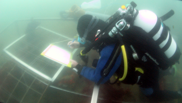
During the 2010 season, work built on past surveys with trench excavations aiming to expose and record more of the buried structure to confirm its form, extent, and condition (see picture below). This started at the north end of the site, where the vessel’s hawse holes were still preserved in-situ and moved towards the southern extreme of the site. Five trenches were excavated revealing substantial timbers below the surface. Few artefacts were encountered during the excavation. However, there were a number of ship hull fixtures and fittings. The depth of sediment over the timber structure is relatively shallow, but as excavation has revealed, there are still substantial timber elements below the surface.
Identification
The archaeological work produced quite a clear image of the type of vessel represented by the seabed remains. The vessel was clearly a large, armed sailing ship, built, probably by the Royal Navy, between 1793 and 1833 at a site likely to have been in south-east England. Moreover, analysis of the copper and the lead hawse holes suggested a vessel that sank sometime between 1800 and 1817. This allowed historical research to be more precisely focused on armed, Naval vessels lost in the vicinity of Alum Bay during the period in question. After careful analysis of over 300 wrecks lost within 10km of Alum Bay, it was clear that the only ship that satisfied all of the known characteristics of Alum Bay 1 was HMS Pomone. As well as the wreckage in Alum Bay, numerous artefacts form this ship are scattered throughout the Needles.
